Friday, October 20, 2017

Shipping and Delivery via Drones; Can it Work?

Shipping and Delivery via Drones; Can it Work?

The global population's contentedness is growing as each day passes. One industry that is particularly impacted by this growth is the shipping industry. Many of the shipping seen today is a product of consumer purchasing, an industry that is booming itself. Companies like Amazon, Google Wings, Walmart, Target, and virtually any other brand-name retail shopping resources rely heavily on the shipping of goods. Historically, the shipping industry has been dominated by water and ground carrying in the form of boats, trucks, and trains. Only in the latest half-century or so have we seen a rise in transportation and deliver of goods via airplane, an introduction that exponentially increased the efficiency and accessibility of shipping. But now, a new technological advancement may be taking the ideas of speed and efficiency to a new level. Drones are small, manned aircraft, capable of flying at considerable heights and speeds. Companies and investors alike show interest in the idea of using drones to deliver, but is this idea feasible when considered in terms of the global industry of shipping? Dan Wang's article entitled, "The Economics of Drone Delivery", highlights pros and cons of this futuristic technology.

Below is a photo of the prototypical delivery drone as depicted by Amazon Prime Air

Image result for shipping drones

Benefits of Drone Implementation

Many of the benefits of drone shipping draw connections to the business-minded individuals looking to cut cost in business affairs, especially in the form of paid-labor. For corporate CEO's and investors, Drones appear to be a way to make more money. Wang's article highlights one such possibility for Amazon in saying, "...a report by ARK Invest, Tasha Keeney suggests that Prime Air could cost Amazon only 88 cents per delivery. If Amazon charged customers $1 per delivery, Keeney estimates, the company could earn a 50% return on its investment in drone infrastructure while offering same-day delivery that is significantly cheaper than current alternatives." This excerpt also brings attention to the decrease in delivery time. As the industry and its technologies increase, consumer demand for quicker delivery times increases as well. Drones could be an unparalleled step forward in this department.

Cons of Drone Implementation

For the most part, drone shipping is an idea with more skeptics than endorsers. One key point of skeptics is seen in the comparison between the production levels of current shipping methods with that of projected productivity of drone delivery systems. Efficiency is a major concern highlighted by this comparison. While delivery trucks can complete multiple deliveries at hundreds of stops per day, the prototypical delivery drone carries one or two items at a time, no heavier than 7 pounds, and at a maximum distance of 10 miles or so (Wang. Flexport.com). Without a doubt, factors like weight capacity, distance, air traffic, inclement weather, etc. all pose as obstacles that need hurdling before this new wave of shipping can happen.

The photo below, via shuttershock shows current forms of shipping (air, train, ground, and ship)

Image result for air, train, ground shipping

Future

To say that drones will completely overtake the shipping industry and its millions of jobs in the near future would simply be unlikely. However, with current advancements in technology and high pressures of consumer-driven markets, it seems reasonable to conclude that drone delivery may begin to make its impact on the shipping industry sooner than originally thought.


Sources

Amazon Prime Air

The Economics of Drone Delivery

Shuttershock

Wednesday, October 18, 2017

The History of Transportation/Redevelopment of River Front in Palakta, Fl (audio,visual)

The Gem City of the St Johns Rivers was established as a trading post in 1821 and today is known as Putnam County, Fl. The name Palatka comes from the Timucuan Indians word Piltakaka, meaning crossing. This is were Indians within the region trades goods with different tribes, such as tools, minerals, and skins. Later , in 1838, the U.S. Government constructed Fort Shannon, after burning the trade post during the American War. Fort Shannon served as a garrison, supply depot, and hospital fort. Palatka had become a very important gateway to the interior of Florida and boats head south. A devastating fire struct the city in 1884 and in 1894 a cold front froze citrus industry.  During these time frames where Indians and early american settlers inhabited Palatka, the use of transportation played a major role in the economy. Boat transportation was a major factor in distributing, trading, as well as travel during the 1800's.

Fast Forward to today's Palatka, Fl.
Palatka is a rural county with a very poor economy with no major public transportation offered to the public.  There are resources to travel outside of the city to neighboring major cities such as the train or greyhound, but nothing for local travel. Ride Solution which is a non profit that provides public transportation is the only thing available to the public. Its plan was to address rural transportation issues but diffused population and rural nature create barriers. The walk ability is slowly being improved as a city plan is under way. A 3 phase plan called Riverfront Revitalization Initiative that plans to create walk able areas down town to promote commercial business use, community events , cyclist, and many more.  However, the ongoing issue of public transportation is a huge issue here in this rural county.  Outside of car use, you don't see many other ways of transit other than walking. There aren't many cyclist due to side walk and existing infrastructure. Its hard to think a rural city with a poor economy and little to know public transportation right off of St. Johns River played a huge part of history and help shape our early economy. 


https://www.youtube.com/watch?v=E6s7tPE3QpI


Sources: http://www.palatkadowntown.com/palatka-history.html
http://palatka-fl.gov/212/Riverfront-Revitalization-Iniative

Can fast buses help ease Atlanta’s traffic nightmare? Bus Rapid Transit (Atlanta, Ga) Article


Bus Rapid Transit idea is very new to the city of Atlanta. Marta currently service as the bus transit system, However, After Fulton county's commissioners recent visit to L.A. El. Monte Station, the city has plans to expand Marta into a BRT system. Both Atlanta & L.A. experience heavy congestion, however, L.A. has more readily available transit systems that Atlanta is looking to adopt.

L.A. Metro’s El Monte Station the eastern terminus of the Silver Line is a two-story facility with 29 bus bays. It serves Greyhound and neighboring Foothills Transit as well as Metro s bus rapid transit line. DAVID WICKERT

"Bus rapid transit is like a MARTA line on tires instead of rails. Passengers board at stations, not bus stops. The vehicles make few stops, and they usually travel in dedicated bus lanes or on highway express lanes like the ones already under construction across metro Atlanta." says Wickert. 

Bus rapid transit is cheaper and can be built within 4 years opposed to 10 years. Fulton County isn’t alone. The City of Atlanta, Gwinnett and Clayton counties and MARTA itself are all considering bus rapid transit lines. However, feedback from the community hasn't been great! This is a new innovative transit systems that can be easily replaced or redeveloped if necessary.  The city of Atlanta currently doesn't have a great mass transit system outside of Marta, so if they are able to execute their plan, BRT could be the next mass transit system for Atlanta. Skeptics say BRT might get you from point a to b, but wont promote walk able communities that could transform Atlanta's car centered commuting patterns. People also say that its the cheap way out. 

Will BRT solve Atlanta's problem?  Maybe, but at-least help with traffic congestion. BRT is only one factor that will help Atlanta's traffic congestion, and more transit systems will be needed until there is a final solution.  


Also there are two addition videos within each source link giving more details on the City of Atlanta's mass transit systems. The first link is the mayor speaking directly to new's crew and the second video is  Fulton's County Commissioner giving more details on buss rapid transit and its expansion into Atlanta.


Sources:
By David Wickert - The Atlanta Journal-Constitutionhttp://www.ajc.com/news/local-govt--politics/are-fast-buses-the-future-mass-transit-atlanta/0ASMeLvSbw3I5SINGiUyHP/

http://www.myajc.com/news/local-govt--politics/can-fast-buses-help-ease-atlanta-traffic-nightmare/FATU9Ri1V0c6m16hrdJQyI/

Transit Oriented Development (TOD)

Transit Oriented Development is the development of mixed- use communities center around quality train/rail systems that promotes walk able and pedestrian oriented neighborhoods.TOD is a growing trend in creating sustainable communities that has great curve appeal, walkable and livable.  This makes it possible to live a lower-stress life without complete dependence on a car for mobility and survival.

photo credit tod.org
 Transit oriented development is regional planning, city revitalization, suburban renewal, and walk-able neighborhoods combined.There are many benefits associated with Transit Oriented Development. Outside of promoting walk able communities, TOD reduces our dependency on driving, reducing carbon footprint or negative impact on the environment , and revitalize urban areas just to name a few benefits.

photo credit tod.org


Sources: tod.org

Monday, October 16, 2017

The Effects of Disasters on Aviation Corporate Income. (News Article)

Three major disasters have rocked the lives of people living in Texas, the southeastern portions of the United States (mainly Florida), and Puerto Rico. Theses disasters (Hurricane Irma, Maria and Harvey) were expected to disrupt the economies of these three areas but their impacts will be felt in many airlines' quarterly earnings, ultimately effecting the entire nation. A recent CNBC article, "Profit declines expected for airlines after storms, costs bite", showed how one of the largest sectors of the transportation field was effected by the storms, not just in the ways we would expect.

While the amount of passengers who flew during the month of August increased by 7 percent, the article explains the many factors that effected and ultimately hurt some of the largest United States airlines. Of course, canceling flights pose huge problems for airlines, not just in the areas that are directly effected but also on other routes that use the planes traveling from cities such as Houston or Miami. The articles cites American Airlines who reported that they had to cancel more than 8,000 flights because of the storms. Hurricane Harvey also had a large effect on the oil industry. The storm closed operations in a large amount of oil refineries in Texas and the Gulf of Mexico. This raised the overall cost of traveling for Americans and airlines. The shut down was so impactful, that according to the article, jet fuel prices were about 20 percent higher in the third quarter than the year prior.

Finally some airlines took time to help the communities that were effected, most notably Puerto Rico. By doing this, the participating airlines ran flights (with crews and equipment) but made no income, taking the money straight from their bottom line. While there are arguments that the positive media attention can create more of a demand, those impacts (if any) will not come in this financial quarter.

This information directly relates to our class in many ways. Aviation is one of the largest forms of transportation and accounts for a sizable portion of our nations GDP. Tourism and trade, among other things, are reliant of aviation. As corporate incomes go down, prices for an average ticket is bound to increase to compensate for the loss. For our transportation network to be equitable and efficient, prices need to be low and accessible for most people. This article also shows an important lesson that we have, and will continue to discuss in the class. Transportation requires many industries to function. A perfect example of this is the impact that the shutting of oil refineries had on the aviation industry. While the two industries are separate, they both need each other to thrive, especially in times of disaster. I believe that this article has many important, and often under discussed topics.

Article: https://www.cnbc.com/2017/10/10/earnings-airline-profits-expected-to-decline.html

References:
Sheetz, M. (2017). "Profit Declines Expected For Airlines after storms, costs bite" Retrieved from CNBC: https://www.cnbc.com/2017/10/10/earnings-airline-profits-expected-to-decline.html

Thursday, October 12, 2017

How Transportation Created and Shaped Tallahassee


Tallahassee began as a Native farmland and hub for exporting goods to places such of St. Augustine and the Pensacola area. Later the same trails used by the Natives would be turned into major roadways once Florida was part of the United States.

The St. Marks trail was also a Native trail that allowed water access to canoe goods where they were needed. This trail would later be turned into a railroad used for shipping and moving people. For example, the railroad was used to move troops during the Civil War.


Works Cited

Native Americans Started the Trail That Evolved into North Florida’s Transportation System. (n.d.). Retrieved October 10, 2017, from http://www.tallahasseemagazine.com/September-October-2009/Following-Ancient-Footsteps/index.php?cparticle=2&siarticle=1#artanc

(n.d.). Retrieved October 10, 2017, from http://www.talgov.com/place/pln-ac-history.aspx

Tallahassee to St. Marks Historic Railroad Timeline. (2013, December 11). Retrieved October 10, 2017, from https://cc2st.com/tales/tallahassee-to-st-marks-historic-railroad-timeline/

United States History. (n.d.). Retrieved October 10, 2017, from http://www.u-s-history.com/pages/h3929.html


Portland, OR: The US's Capital of Multimodal Transportation

Here's the link, too! https://youtu.be/EEqwIe1xbck


Portland, Oregon’s urban form has been shaped by its transportation infrastructure. Portland recognized the negative impact of automobiles on its resident’s quality of life and proactively began to support alternatives to the car.


Portland is a city in Northwestern Oregon built along the Willamette and Columbia Rivers. Railroads were later constructed with the city limits (PDX History, 2017) and this combination of river access and rail made Portland a center of regional trade for products like fish, timber, wheat, and cattle.


 Because Portland is in an area with so many waterways, bridges have played an integral role in the city’s development. The first bridge in Portland was the Morrison Bridge. Constructed in 1887 (Portland Bureau of Transportation), it crosses the Willamette River and allowed development to expand from the west banks of the river to the east. Today, the city has 160 bridges.


By 1890 Portland had its first electric street car, which reduced the operating costs in half from when the streetcars were horse-drawn (PDX History, 2017). The electric streetcars made it easy to travel up Portland’s steep hills (Oregon Experience: Streetcar City, 2011). Streetcars in Portland resulted in a gridded street pattern.


In 1900, Oregon began to see its first automobiles. Oregon was the first state with a gas tax, and by 1920 there were over 700 miles of paved roads (Portland Bureau of Transportation, 2012).


Post WWII the car exploded in popularity, creating problems with congestion. Burnside Street is a central transportation corridor in Portland, and was widened to eight lanes in 1931 (Portland Bureau of Transportation. Since the buildings were adjacent to the existing sidewalks, contractors placed the facades of the buildings on rollers and moved them away from the road to create right-of-way for travel lanes, on-street parking, wider sidewalks, and aesthetically pleasing lighting. The Burnside Widening project occurred during a time when the state of Oregon was prioritizing traffic efficiency. Federal funding for the National Highway System further affected the land use patterns of Portland by spurring the growth of suburbs as seen in other areas of the United States (Portland Bureau of Transportation, 2012).


Come 1969, Portland saw the creation of the Tri-County Metropolitan District of Oregon aka TriMet (Portland Bureau of Transportation, 2012). Portland was experiencing traffic congestion and economic decline in downtown districts. TriMet sought to address these problems by re-evaluating land-use and investing in transportation alternatives (Portland Weird). Their first step was to de-privatize the bus system, and expand it to suburban areas.


Although bicycles did not gain popularity until the 2000s, Portland’s first Bicyclist Road Map was published a century before this time (Raynor, 2016). Cycling was widely seen as recreation, but that changed as facilities improved and more people chose to cycle to work. Portland’s narrow streets, a legacy of the streetcar, made it a safe city for bike commuters. In 2015, the Portland City Council voted to fund a new bike share program to support alternative modes for travel (Oregon Live, 2015).


TriMet began construction on a light rail system in 1978. Once completed in 1998, there were 127 cars operating on 52 miles of track. They called it MAX, Metropolitan Area Express. MAX is the perfect example of transit-oriented development, or TOD. It connected all of the suburbs to the city center, reducing traffic congestion. Portland has 625 buses operating on over 100 lines (Portland Bureau of Transportation, 2012) . All of them use an environmentally friendly biodiesel fuel.  Additionally, 254 minibuses and 15 vans provide paratransit options (Portland Bureau of Transportation, 2012).


In 2007, The South Waterfront District and the Oregon Health and Sciences University privately funded the Portland Aerial Tram that serves their patients, employees, and students for free and others at an affordable fare. This aerial tram is one of two in existence and really showcases Portland’s innovative spirit when it comes to multimodal transportation.


As people were able to travel longer distances in shorter amounts of time, they chose to live further from the city center. In response, the city of Portland invested heavily in alternative modes like rail, bus, and cycling. Portland has always prioritized multimodal development as the cornerstone for resident’s ability to live, work, and play. Because of this, Portlanders enjoy the luxury of greater accessibility and mobility than most other US citizens.


Portland Bureau of Transportation. “Portland Transportation History Timeline” (n.d.). Retrieved from https://www.portlandoregon.gov/transportation/article/65562


Portland Bureau of Transportation (2012). Keeping Portland Moving. Retrieved from https://www.portlandoregon.gov/transportation/article/500905


Portland Bureau of Transportation. “Burnside Street History” (n.d). Retrieved from https://www.portlandoregon.gov/transportation/article/295412


Raynor, Rand. (2016, May 12). Portland Transportation History. Retrieved from https://www.youtube.com/watch?v=EjI9JQ_KFqY


Portland (n.d.) In The Oregon Encyclopedia online. Retrieved from https://oregonencyclopedia.org/articles/portland/#.Wd2Zh2hSxPY


PDX History. (2017). Retrieved from http://www.pdxhistory.com/


Portland Weird. “Portland Public Transportation” (n.d.) Retrieved from https://portlandweird.weebly.com/public-transportation.html


Newzgoddess. (2011, February 9). Oregon Experience: Streetcar City. Retrieved from https://www.youtube.com/watch?v=rVXRbPrDm68


Njus, Elliot. (2015, September 23) “Portland City Council signs off on new bike-share program”. Oregon Live. http://www.oregonlive.com/commuting/index.ssf/2015/09/portland_city_council_bike-sha.html

Audio/Visual Project - Austin, TX

              AUDIO/VISUAL AUSTIN, TEXAS
         
              Established in 1839, Austin, Texas is now the fourth most populated city in the state. However, it took great leaps in improvement of transportation and infrastructure for the city to achieve its current status. Austin’s development and expansion as it relates to transportation can be linked to a few key factors. Upon closer examination, it becomes obvious how these key factors not only helped to develop new modes of transportation for the city’s population, but they also played a significant role in shaping the city as it grew. Now, almost 200 years later, Austin is a bustling metropolis with a population numbering just under 1,000,000. Updates and developments of the transportation made all of this possible.
Origins

                With the introduction of the first ferry in 1846, water was the first true form of transportation, aside from walking and horseback. Austin, immediately sprouted along a travel corridor on the banks of the Colorado River. Due to the heavy reliance of water travel, a map of Austin from 1873 shows characteristics that are recognizable in many cities that developed around a water way. A grid pattern defines the initial shape of the city, with all streets running to and from the river. A look at the early map also displays how the larger, more developed portion of the city is located only three blocks from the water’s edge. In a comparison to today’s Austin, this map helps to explain why the cities density is higher in places centered on the river. It seems as though the river gave birth to the city, and outward expansion begins at this central point.

 Related image
         Austin, Texas 1873 (Augustus Koch, 1873)              Present-Day Austin, Texas (Rob Greebon)  http://www.wikiwand.com/en/Timeline_of_Austin,_Texas http://www.imagesfromtexas.com/photo/downtown-austin-skyline-from-the-hyatt-7-3/
                                 
Forms of Transit

                     In information collected from the Austin History Center, bridges, the automobile, an introduction of mass transit, and the first municipal airport were all key elements in shaping the city of Austin. Each of these events in the city’s timeline individually and uniquely effected the way in which the infrastructure of the city developed.
                    Bridges were the first innovation in transit to make an impact on the shape of the city. Before bridges were implemented, the crossing of the Colorado River was difficult and often dangerous. The first few bridges were made of connected pontoon sections and allowed light travel in the form of people, horses, and small wagons. But, despite being small and minimal in functional practice, the first few bridges allowed for an exponential increase in safe access in and out of Austin. Naturally, with more access comes the influx of people. The city currently maintains four major bridges that provide transportation routes over the Colorado River, and make it feasible for people, businesses, parks, etc. to be located on either side of the river.
               After bridges, Austin saw its first form of mass transit. Beginning in 1875, horse-drawn street cars took on the concept of transporting groups of people (Austin History Center). This form of transportation was important because not only did it eliminate much of the pedestrian traffic, but it meant that efficiency of travel was exponentially improved. Though streets and roads were still only dirt and gravel, and the city's size still relatively small, having a form of mass transit made travel within the city quick and easy. The molding and design of streets in a way that benefits the Austin's mass transit carries through to today, but on a much larger scale with forms like metro-rail, super shuttle, capital metro bus line, taxis, and shuttles (Austintexas.org). Analyzation of aerial views show how mass transit heavily impacted design in down-town Austin. Streets are wider and more organized, but still hold their original grid-like patterns.      
The automobile was the next facet of transportation brought to the Austin area. Although cars were only owned by the wealthiest families in the city at first, the presence of cars brought about the need for new streets as well as upgraded infrastructure to the already established streets. For a city previously dominated by pedestrian, boat, and horse travel, the automobile meant further expansion on Austin's size and scale was imminent. Once the automobile became affordable and commonplace, the city began branching out in all directions as its population could now commute to and from work at much greater distances.     
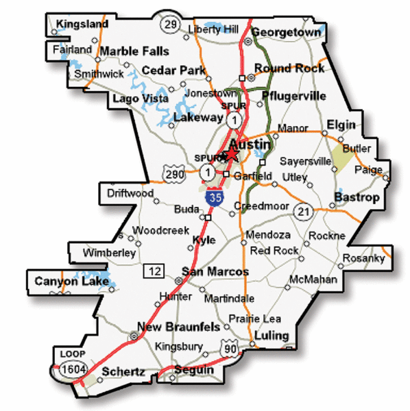
Like every major metropolitan city in America, Austin's increase in population, automobiles, homes, and business eventually led to a pressing need for highway system. After a long construction period, I-35, Austin's first freeway, was opened to the public in 1965 (Texasfreeway.com). I-35 ran north and south, and urban sprawl continued following the freeway away from the city. The current boundaries of the city are structured in a way that emphasizes this affect. Large housing communities and neighborhoods line the edges of the freeways of Austin, running both east and west as well as north and south. More modern movements like suburbanization have added an even greater distinction of this affect, as the city and its population continue to grow.
Austin Highway Map
    (Mappery.com)

The most recent development in transportation has had an unparalleled impact on the density and socio-economic structure of Austin. Converted from an air-base, Austin-Bergstrom International Airport was completed in 1999 and the impact was immediate (Austintexas.gov). The airport, unlike other forms of transportation improvements, didn't have much impact on the expansion of the city. Rather, the airport let to an increase in density of high-rise and commercial buildings in downtown Austin. With an international airport located within city limits, it was now possible for large industry and corporation to move in. Many of the buildings that shape Austin's skyline are these types of businesses.
From small beginnings to its current state, Austin, Texas is a perfect example of how transportation and its increase can help to shape a city. Both geographic range and physical features, highlight the fact that the city is full of examples of this phenomenon.

Informational Sources:

Below is the link to our audio/visual presentation. ENJOY! (sources for the presentation are listed at the end)


Boston Audio/Visual Project

https://youtu.be/FpZ3V7IcD74

For our audio/visual project, we selected one of the oldest cities in America- Boston, Massachusetts. This city has been the site of some of the most influential and historical events in our country's history. Similarly, some of the most important innovations in transportation systems have occurred within the city. From the first ferry system during pre-revolutionary times to the construction of the county's first subway system, Boston has pioneered the way people think about transit in our country.

This presentation begins by examining the origins of Boston, and how the earliest settlers traveled throughout the city. It goes on to highlight the new forms of transportation throughout the years, and notes the socioeconomic changes that led to these inventions. While the main focus of this presentation is the history of travel, it is also deliberate in explaining the forces in urban development that spurred the evolution of transportation.

We hope you enjoy the presentation, and be sure to turn on closed captions if there are any issues with the volume.

Badar, Askia, Michael Audio/Visual Project on Dubai

https://www.youtube.com/watch?v=5BXvC9x-PFA


Before the 1970s, Dubai was a place with very little and located in a desert region. Through new tactics in transportation and new infrastructure, Dubai quickly became a city going through a rapid expansion. One big project was the Al Maktoum Bridge. Managing this new traffic became a new issue and changes had to be made. These solutions called for new plans involving the Road and Transport Authority to step in and bring about changes to the Metro, buses, and taxis. Growth continued through the 2000’s until an economic crisis in Dubai. Dubai became a city of quick success, and a large part of that success had to do with the the new infrastructure that was built and the way the transportation systems adapted to the newly expanded city. Needless to say transportation had a large role to play in making or breaking Dubai has an expanding city.

Amsterdam Audio/Visual


Amsterdam was founded in 1250 as a fishing town. Originally Aeme Stelle Redamme, the Dutch name translates to Dam in a Watery Area. The first canals in the city were dug as moats for defense but, after the walls around the city were build the interior moats were transformed into canals, and were used to transport goods. Not only did the canals serve as a transport for goods inside the city, but moved goods from the city to ships out in the canal, then all over the world.  (Amsterdam.info, 2003-2017)  

In the 17th century this trade process exploded, and the city grew, quadrupling its size and upgrading its waterways. These waterways allowed ships to come into the port, bring their goods into the city and deliver the goods directly to the shops in town. There were also nine specialized floating docks that were markets for local citizens (Amsterdam.info, 2003-2017). The waterways were not the only infrastructure change in Amsterdam at the time, the streets also grew a great deal. In 1641, an English tourist said “The Streets so exactly straite, even & uniforme that nothing can be more pleasing (Jordan, p. 23)”.  By directly approaching the stores by smaller boat, the canals maintained their usefulness in the city, and were maintained to keep trade flowing.

With the invention of the car a city made of waterways was not conducive for 20th century travel. The city began to fill canals to make room for streets and parking. There was a lot of resistance from citizens about the installment of roads. With a mild climate and few hills, there is a large cyclist population in Amsterdam (Amsterdam.info, 2003-2017).  After the first World War, there was a huge import of low cost German made bikes in to the Netherlands. With the low cost of bikes, the rail system had to increase their prices, which decreased train ridership and increased cycle use (Jordan, p. 56).  When it came to cars in the 1920s there was a staggering difference between that in the US and Holland. In America, there was one car for every 3.3 people, and one car for every 185 people in the Netherlands (Jordan, p. 100). The size of cities was directly affected by the availability of cars. A Dutch tourist in 1937 was amazed that roads could run for 25 miles and still be within the city limit Chicago, while it was rare in Amsterdam to travel more than a mile on a road and remain in Amsterdam city limits (Jordan).

During the Nazi occupation of the Netherlands, Amsterdam’s bike pride was on full display. When required to turn in their bikes in 1942, one resident said “This is how it is: if you touch an Amsterdammer’s bike, you touch his life (Jordan, p. 206).

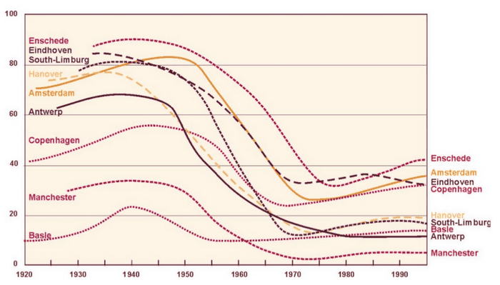
In the 1950s, around 80% of trips made around Amsterdam were by bike. In 1970 that number had plummeted to near 25%. The cyclist citizens of Amsterdam were seemingly under attack. Their bike paths were being replaced with roads and they were being thrown into a dangerous mode of transportation (Zee, 2015).


In 1960, a prominent street in Amsterdam, Leidsestraat, was “renovated” giving new piping underneath, with telephone cables and tram tracks. Along with this renovation, Amsterdam’s first major cycle ban on a single street began. Only pedestrians, motorists and tram users were allowed. In 1961, the temporary ban became permeant.  Similar to the population boom in the 1600s, the number of motorists in Amsterdam quadrupled between 1960 and 1970. Pro-car political parties began to earn seats on the city council and talk of filling in canals began to seem much more real. (Jordan, p. 295)

In 1971, there were 3,300 traffic casualties, more than 400 of which were children. There were many activist movements and protests to try and stop the damage being done to cyclists, one of which was Stop de Kindermoord which in English is “stop the child murder” (Zee, 2015).

A protest on a major road in Amsterdam. (ejatlas.org)


Stop de Kindermoord was very active, they held demonstrations and were frequently in contact with the Dutch authorities. The groups were so much in contact that Stop de Kindermoord became subsidized by the government (Zee, 2015).  This step allowed the organization to become much more involved in the urban planning of Amsterdam. Other protest organizations would paint bike lanes in roads that were dangerous for cyclists. With much effort and protest, the government got involved. With the large amount of traffic related deaths and the 1973 oil crisis, the prime minister urged Dutch citizens to adopt a new lifestyle and the government implemented car free Sundays (Amsterdam.info, 2003-2017). These car free Sundays were a blast into the past for Amsterdammers, they experienced a city again dominated with cyclists and pedestrians.

Moving into the 1980s, politicians began to see the advantages of cycling. They began to build more multi-use streets, where cyclists and cars share the road. “Between 1980 and 1995, the number of people cycling in the city center had increased by more than 29 percent, while the number of those driving had dropped by 24 percent (Jordan, p. 371)”. In the decade of the 2000s, bike thievery was the focus of a very effective Amsterdam city policy, as the theft rate decreased by half (Jordan, p. 378).

This transition from cycle heavy, to car heavy and back to cycle oriented travel has kept Amsterdam a bustling city by staying on top of transportation policy.  The physically small city with hundreds of thousands of people living in it is an amazing example to dissect. As much as Amsterdam developed with different political presences and technologies, I believe its development is in the longevity of its culture. The city does not have a major highway in it, it has waterways intertwined, as it did in the 1500s. I think the cyclists helped to preserve the culture of Amsterdam, even if it was unintentional. Today, Amsterdammer’s bikes are prevalent throughout the city, and the presence of 21st century technologies are apparent but it is well known - Amsterdam is a city meant for biking.

Audio/Visual Project Link: 


(Sorry, the video would not upload to youtube so I had to take a video of it with my phone)


Sources
Amsterdam.info. (2003-2017). The history of the Amsterdam canals. Retrieved October 05, 2017, from Amsterdam.info: https://www.amsterdam.info/canals/history/
Citi Io. (n.d.). Amsterdam Has Officially Ran Out of Bicycle Parking. (C. Io, Producer) Retrieved October 09, 2017, from Citi Io: https://www.citi.io/2015/04/08/amsterdam-has-officially-ran-out-of-bicycle-parking/
Jordan, P. (2013). In The City of Bikes. New York, New York, USA: HarperCollins.
NEHA. (1993). Economic and Social History in the Netherlands. (D. P. Boomgaard, Ed.) 5, 5-205.
netherlands-tourism.com. (2017). Netherlands Tourism. Retrieved October 06, 2017, from Netherlands Tourism: http://www.netherlands-tourism.com
PlanetWare. (2017). 16 Top-Rated Tourist Attractions in Amsterdam. (PlanetWare Inc.) Retrieved October 4, 2017, from http://www.planetware.com/tourist-attractions-/amsterdam-nl-nh-amst.htm
Rota, S. L. (2017, May 13). Stop de kindermoord - against children death caused by motor vehicles, The Netherlands. Retrieved October 09, 2017, from Environmental Justice Atlas: https://ejatlas.org/conflict/stop-de-kindermoord-stop-the-child-murder-protest-for-children-deaths-caused-by-motor-vehicles
Sarah. (2015, November 06). Rules to Cycle Amsterdam Like a Local. Retrieved October 09, 2017, from Traveling Europe: http://www.travelingeurope.biz/rules-to-cycle-amsterdam-like-a-local/
Thompson, F. M. (2014). Amsterdam Travel Advice: Tips for Cycling in Amsterdam. Retrieved October 4, 2017, from asthebirdfliesblog.com: http://www.asthebirdfliesblog.com/posts/tips-and-advice-for-cycling-in-amsterdam
TravelSmart Ltd. (2000-2015). European Continent. Retrieved 10 06, 2017, from World Guides: http://www.world-guides.com/europe/
Zee, R. v. (2015, May 05). How Amsterdam became the bicycle capital of the world. Retrieved October 08, 2017, from The Guardian: https://www.theguardian.com/cities/2015/may/05/amsterdam-bicycle-capital-world-transport-cycling-kindermoord#img-3